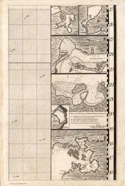
Waterways maps: A Map of the British Empire in America with the French and Spanish Settlements adjacent thereto (detail)
— sheet 16: harbours in Cuba, Jamaica and Martinica
Bibliographic details
- Mapmaker: Henry Popple (fl. 18th Century)
- Date: 1733
- Published: W. H. Toms & R.W. Seale (London, 1733)
- Scale: 1:2,000,000
- Source: Rumsey Collection / image no: 2874018
- URL: David Rumsey Map Collection, Cartography Associates
- © Rumsey Collection, 1998
Includes views of "The Havana", the "Bay of St. Iago in Cuba", "Kingston harbour in Jamaica", "A plan of the harbour of Port Antonio in Jamaica" and "Fort Royal in Martinica".
This sheet is one of 20 sheets comprising the overall map. Some sheets, such as sheet 16, are meant to run along the right-hand edge of the fully assembled map.
See also Sheet 12 from the same map.